 |
|
|
Architecture,
Arts & Crafts,
Climate,
Flora & Fauna,
Food,
Geography,
Government & Districts,
History,
How to Get Around,
Religion & Custom,
Traditional Music |
|
 |
|
|
| |
|
| Geography
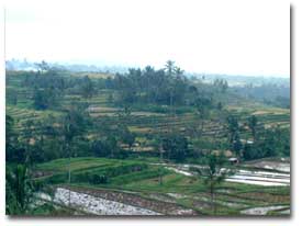 Bali
is a small fertile island midway along the string of islands
which makes up the Indonesian archipelago, stretching from
Sumatra in the north-west, to Irian Jaya, on the border of
Papua New Guinea, in the south-east. Bali is volcanically
active and extremely fertile. Bali has an area of 5620 sq
km, measures approximately 140 km by 80 km and is just 8 degrees
south of the equator with lots of mountains, volcanoes and
lakes, all surrounded by huge areas of rice fields and of
course, the beach areas. About 70% of the island is agricultural
ground, 22% consists of forest and 8% is left uncultivated. Bali
is a small fertile island midway along the string of islands
which makes up the Indonesian archipelago, stretching from
Sumatra in the north-west, to Irian Jaya, on the border of
Papua New Guinea, in the south-east. Bali is volcanically
active and extremely fertile. Bali has an area of 5620 sq
km, measures approximately 140 km by 80 km and is just 8 degrees
south of the equator with lots of mountains, volcanoes and
lakes, all surrounded by huge areas of rice fields and of
course, the beach areas. About 70% of the island is agricultural
ground, 22% consists of forest and 8% is left uncultivated.
Gunung Agung, known as the 'mother mountain', is the highest
of the volcanic mountains at 3142 m. Another worth visiting
is Mount Batur (1717 m) with its huge mountain lake. These
mountain areas have a wet climate most of the year, with very
cold evenings and nights, when temperatures can drop to 8
C occasionally; the lower areas of Bali have basically two
seasons, wet and dry.
South
and north of the central mountains are Bali's fertile agricultural
lands. The southern region is a wide, gently sloping area
where most of Bali's abundant rice crops are grown. The south-central
area is the true rice basket of the island. The northern coastal
strip is narrower, rising more rapidly into the foothills
of the central range, but the main export crops - coffee,
copra and rice - are grown here. Cattle are also raised in
this area
|
|
| |
|